Govan Active Travel
This is a report building on the designs provided by the connecting greater govan project to facilitate active travel through the Govan area and develop it economically and culturally.
First I will present the governing idea that drives the feedback and then show 3 edited documents that detail in what way the street layout can be changed to achieve the goals presented. The final section makes a case against 2-way cycle lanes before concluding.
Part 1 : Govan Cross and Public Space
The first part of the feedback is to question the place of govan cross and the way it serves the community. As of today, Govan cross, and its main street govan road, serve as a carrier of through traffic, as well as a parking resource for non-residents.
The goal of the following map is to transform the role of Govan Rd from a through-traffic road and parking spot, to a street that facilitates pedestrian access, wheelchair access, and cycling. With the aim to create more spaces for families, shops, and on-street activities like markets or events. All while allowing access to motor vehicles for people with mobility challenges, deliveries, and resident parking.
This is achieved by creating a large pedestrian-only space at the core of Govan cross, allowing the streets to be decorated with trees, bushes and benches, and the extra space to be used for events, markets, and food stalls.
- Green is the pedestrian-only zone without motor vehicles
- Orange is the resident traffic access for motor vehicles
- Red is the through traffic for motor vehicles
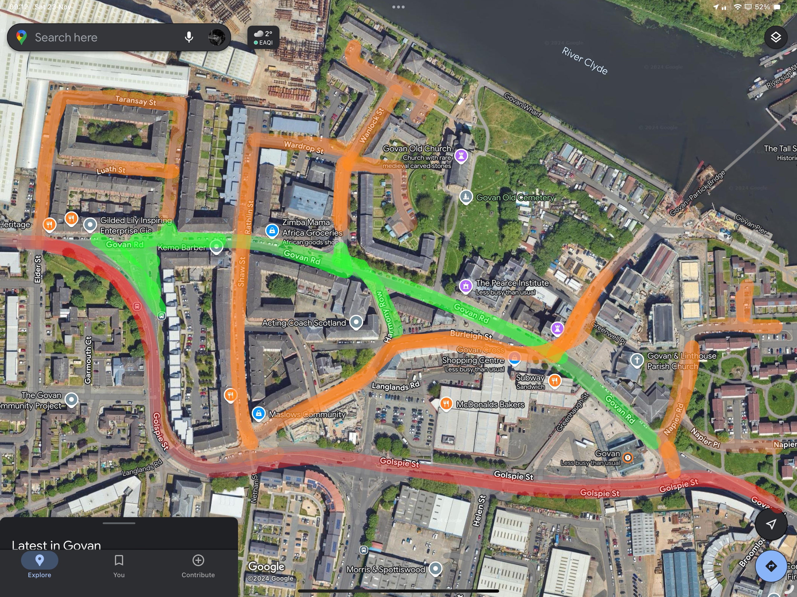
This layout provides 4 opportunities for place-making, from east to west:
The Area Between Govan Subway Station and the New Bridge
The opening of the bridge towards Partick and the Riverside Museum is a great opportunity to revise the way visitors are expected to access it. As of today, once a visitor exits the subway station, they have to cross a busy road, often littered with parked cars, hindering visibility, to reach Water Row and cross the bridge. What is more, the space taken by the road prevents any future businesses from developing by capitalising on the additional foot traffic.
Restricting access to vehicles between the station and water row greatly facilitates access to the bridge for people with mobility difficulties and creates an additional space for the community. Vehicle access to Water Row for residents, deliveries, and visitors is guaranteed by Burleigh St, which itself would become accessible via Golspie St.
The Area in Front of the Pierce Institute
The Pierce Institute is an important community hub in Govan, but as of right now, it is only directly accessible by 4 parking spots in front of it. Pedestrian access is difficult due to the high speed at which vehicles traverse Govan Rd, and cycle access is non-existent. Pedestrianising the street ensures easy access from the subway station. It also creates a plaza where both the Pierce Institute and the William Pierce statue can stand on uninterrupted grounds. Finally, the place provides dignified access to the Old Govan Church, a building whose historical importance has been too long neglected.
The Area in Front of the Lyceum
The Lyceum building is of great importance to the community, as the current plans to reclaim it can attest, and it is paramount that its surroundings reflect that. Today, the intersection in front of the lyceum building entirely yields to through traffic, ensuring that the perception of the lyceum building remains that of a curiosity on the side of the road rather than a place to be celebrated by the local community. Future plans should ensure that the area in front of the Lyceum building is a place for people. And is starts with creating that space for the people.
The West Intersection Between Golspie St and Govan Rd
Today, this intersection is a source of traffic delay, pedestrian confusion, and unsatisfactory road maintenance. It is clear that this intersection has failed to serve the local community. The proposal is to remove the intersection entirely, and employ the additional space for a plaza that would bring foot traffic to the surrounding businesses, and create a space for children and families to enjoy. The space could also host some food trucks to serve the workers of the area and markets for the residents on the weekend.
A Note About Bus Access
This proposal removes 3 bus stops along Govan Rd. Those stops are currently served by the buses M23 and M26 from McGill. Instead of going through GovanRd, they will need to stop at the south of the subway station where the current x19 stop, and follow the same pattern of stops (Govan Interchange, Helen St, Govan Rd). This is, in fact, a good thing, since anyone going west, towards QUEH, currently, has to choose whether to bet on bus 23 to come in first and wait at the north bus stop on Govan Rd. Or bet on the x19 and wait at the south bus stop on Golspie St. By consolidating both bust stops, this coinflip goes away and everyone is guaranteed to board the fastest bus westward. Additionally, all buses now make use of the fast link, instead of getting stuck at traffic lights on Govan Rd. Finally, access to Govan Rd is not significantly hampered since the bus stops at the west and east remain relatively unchanged, the new bus stops would be at most 50m further. The Old Govan Church is the point of interest most affected by the removal since it loses the bus stop in front of it served by the 23 and 26. Thankfully, removing this bus stop only increases the walking time by 3m, to reach the stops currently served by the x19, it increases the foot traffic in front of the local businesses.
Part 2: Detailed Plans
This section provides detailed changes to the proposed design in the form of edited plans. These changes explain how the above design goals can be achieved in practice. There are three plans tracing
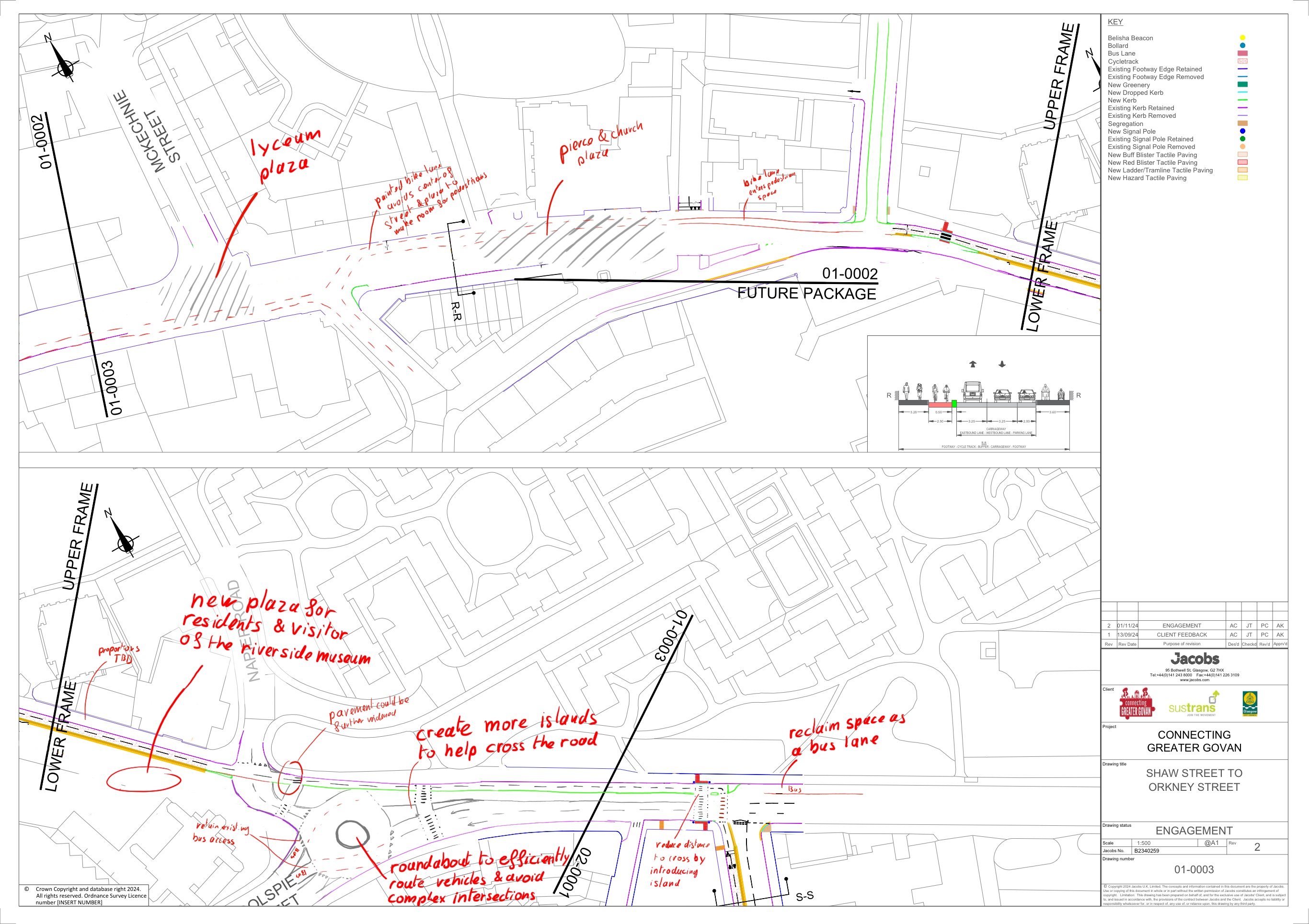
The plan to pedestrianise Govan creates multiple opportunities for people and businesses to use the space freely. It also fluidifies vehicle traffic by directing through traffic via Golspie St and removing traffic lights and sources of road conflict.
East access to Govan Rd
The east access of Govan Cross is rendered difficult due to multiple streets joining at slightly off angles. Currently, most of the space is used by the intersection between Govan Rd and Golspie St. The roads are wide, the traffic lights often induce jamming and crossing the intersection as a pedestrian and a cyclist is challenging.
The new design aims to safely bring cycle traffic from Govan Rd to Orkney St, while enabling pedestrians to cross safely at multiple junctions. Vechicle traffic is also improved by removing traffic lights, using the expansive space at the interesection to build a roundabout, and allowing residents to access Napier Road and Govan Road, using the layout shown above.
Govan Rd and the Town Centre
With the pedestrianisation of most of the town center, access to businesses, points of interests (Old Govan Church, Riverside Museum), and community destinations (Pierce Institute) is made easier than ever. The additional room creates space for adults to gather and kids to play. The lack of private vehicles guarantees easy access for delivery vehicles, emergency vehicles, and people with mobility difficulties. Bike lanes are pushed to the side to leave room for pedestrians and do not require any grade separation.
GovanRd/Fairfield & West access to Govan cross
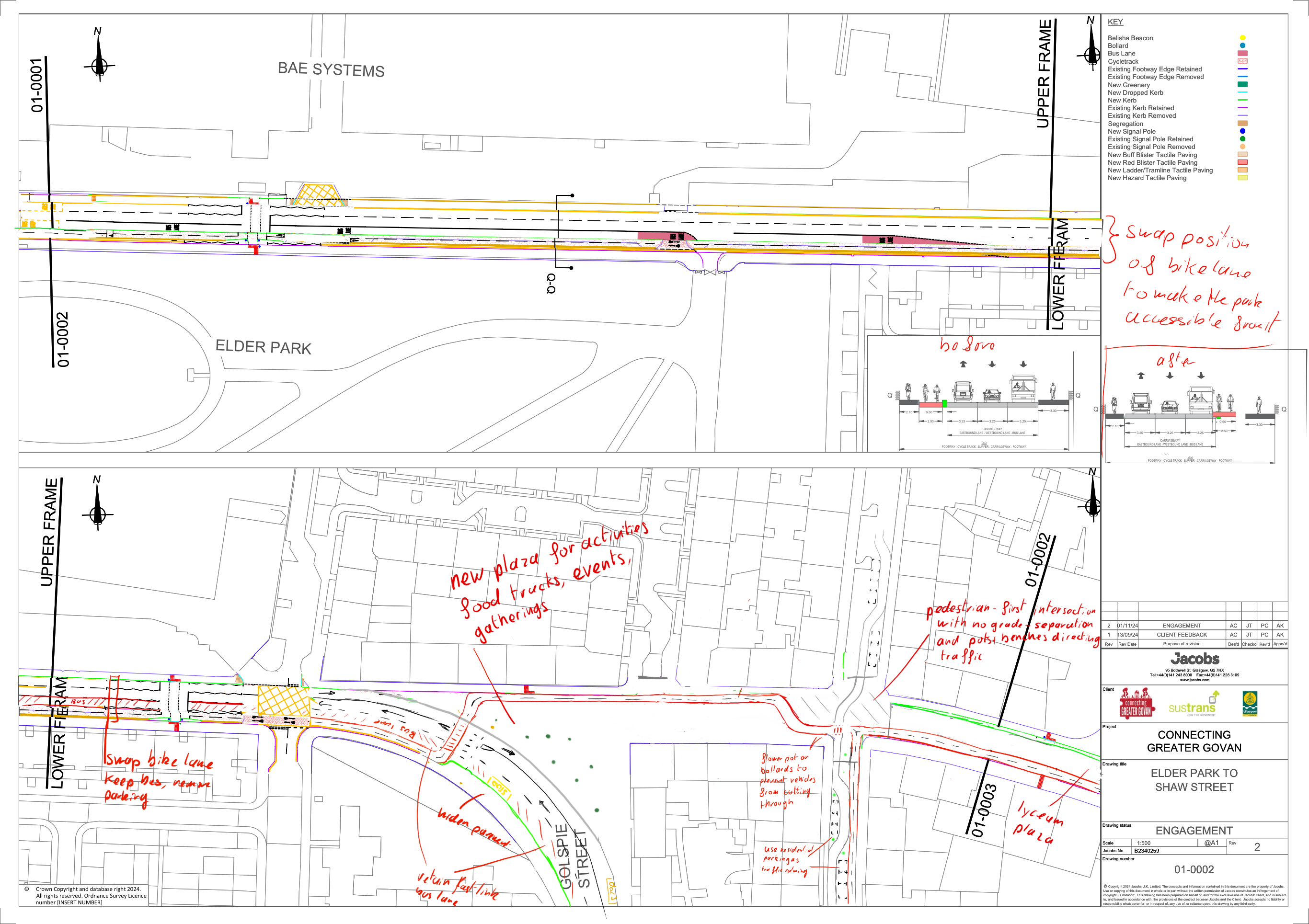
Govan connects to its historical roots as a ship building neighborhood, but the current street layout makes accessing this history difficult and unpleasant. The core of the proposed layout is to provide a new public space obtained by removing the intersection with Golspie St and diverting through traffic away from the centre.
Govan Rd West Intersection with Golspie St
This intersection, as of today, is unsatisfactory. The traffic signals create delays, the layout does not leave any room for cyclists or pedestrians, access to businesses is limited, and access to the fairfield museum is unpleasant by foot from the station due to the amount of noise and polluting traffic at the intersection.
To address those shortcomings, the proposed design removes the intersection altogether, adds zebra crossings for bikes and pedestrians, and creates a new space for people to use and congregate. This space should boost access to local businesses by providing outdoor seating, space for play, and opportunities to develop new businesses like markets or food trucks. It also makes access to the Fairfield Heritage Museum by foot much more pleasant from the subway station and greatly increases access to businesses for pedestrians and cyclists. The added space can accommodate outdoor seating, food trucks or seasonal markets. The fastlink bus lane remains unaffected and the connection to Elder Park is seamless
Elder park bike lane
The change is simple: move the lane to the south of the road so that cyclists can access the park without endangering themselves, or endangering pedestrians.
Govan Rd and Linthouse
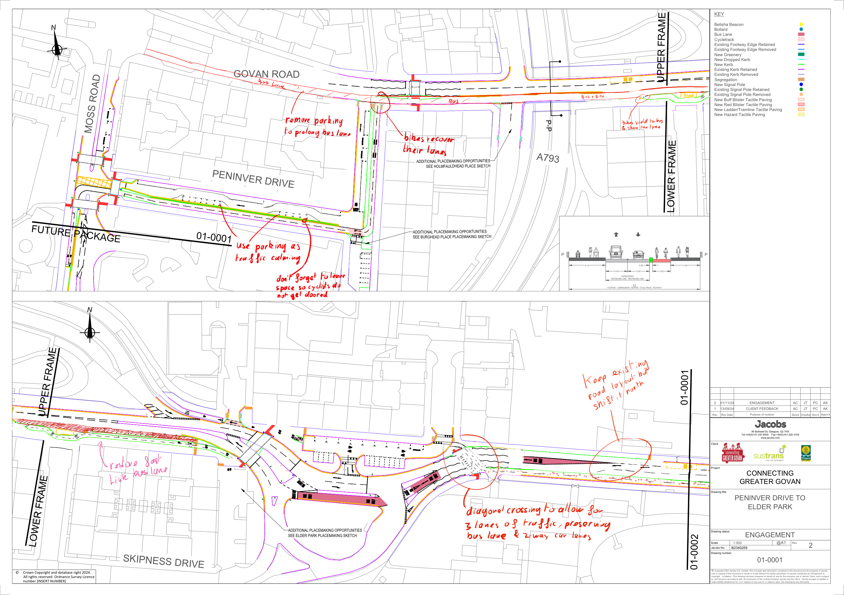
The final section of this feedback document concerns the Linthouse neighborhood and its connection to Govan Rd. The original design removes a much-needed bus lane, this proposal reinstates the bus land and explains how to make the south bike lane around Elder Park connect with the interchange.
North West of Elder Park
The large intersection at the northwest of Elder Park is notoriously difficult to navigate by bike. The proposed change simply takes into account the fact that the bike lane is now at the southmost lane of the street. It keeps the current road design for vehicles with 1 bus lane and 2 car traffic lanes. It also reinstates the fast link bus lane west of the exchange while keeping the proposed bike lane.
Towards QUEH
Further west, the bike lane merges with the bus lane for the duration of the bridge and the next block. This is due to space constraints on this specific stretch of the street, keeping the bus lane is of utmost importance given its connection to QEUH. The bike layout around Burghead Pl and Peninver Dr remains the same, with added traffic calming in the form of parking space allocated on alternating sides of the road. The bus lane is extended all the way to the intersection of Govan Rd With Moss Rd, again to avoid delays incurred by private vehicles when reaching the hospital.
General concern about 2-way bike lanes
One of the issues with 2-way cycle lanes, is that access to the points of interest are guaranteed only from one side of the road. If a cyclist wishes to access a business, or a building, across their designated cycle lane they have three choices, all of which are bad:
- Cross the road through oncoming traffic on both sides
- Cycle until reaching a crossing, cross and join the car lane on the opposite direction
- Cycle until reaching a crossing, cross, and join the pedestrian pavement.
Those three situations are illustrated in the image that follows:
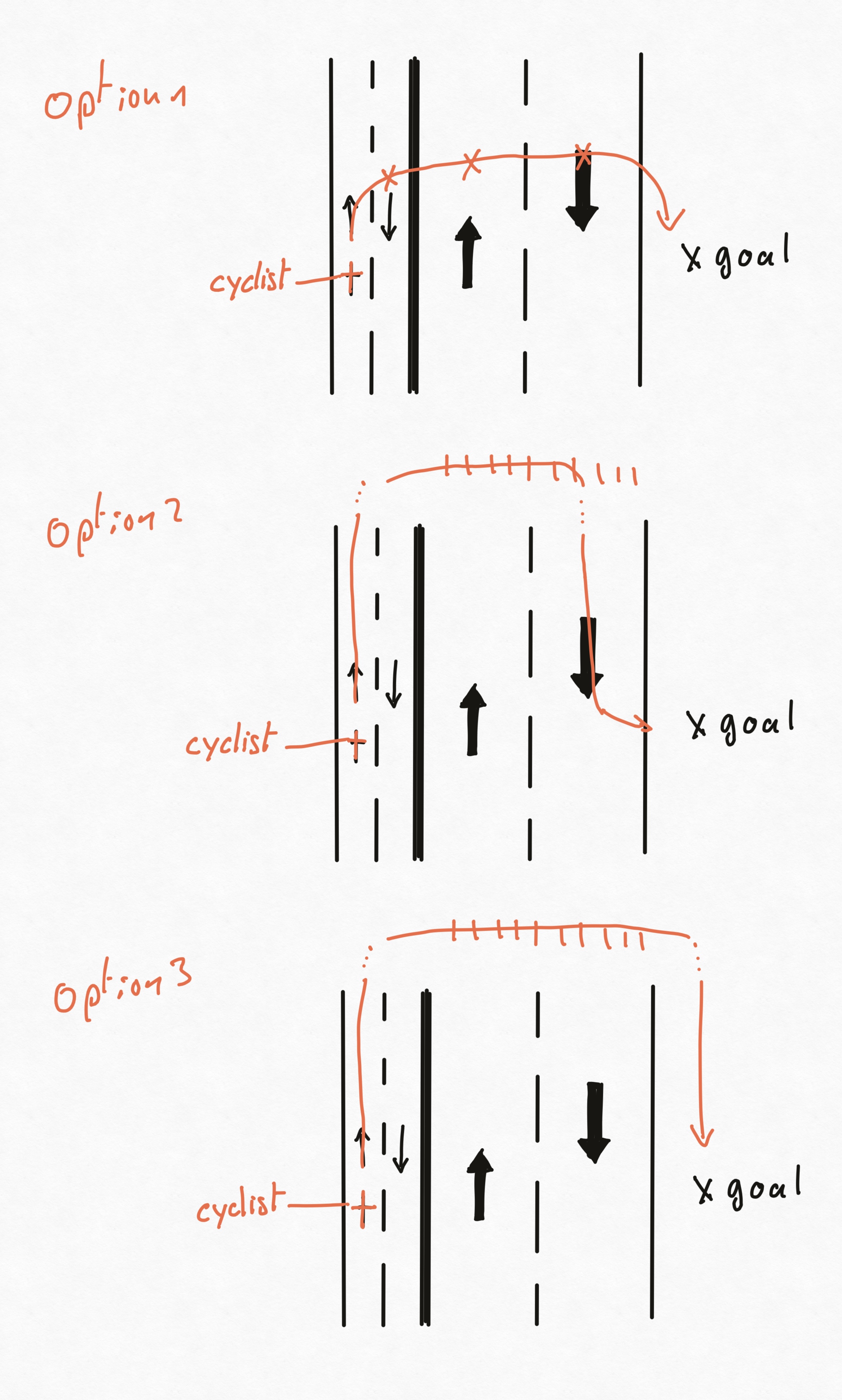
In the first scenario, the cyclist will encounter 3 sources of conflict: Incoming cycle traffic, and two lanes of vehicle traffic. This is in the best-case scenario where there is no parking and only two car lanes. This outcome is the most direct and the most dangerous, failing to protect cyclists from motor vehicle traffic.
In the second scenario, the cyclist does not encounter any conflicts but does not make use of the bike lane on the last stretch of the trip. While this is safer for the cyclist, it also questions the role of the bike lane as a tool to protect different modes of transit, since, in this case, the bike lane fails to protect the cyclist on their way to their destination.
In the last scenario, the cyclist does not encounter any conflict either, however, it creates conflicts with pedestrian traffic that is now put in danger by the cyclist. Again this questions the role of the bike lane as a tool to protect multi-modal forms of transit. We built a bike lane to protect pedestrian from bikes, yet, they end up sharing the same space.
In conclusion, 2-way cycle lanes excel when all the points of interest are gathered on the same side of the road. Whenever that is not the case, they fail at their role to protect the users of the street. The proposed plans keeps 2-way bike lanes along Elder Park and in the Linthouse area because all the points of interest are on the same side. But it would be nice to eliminate 2-way cycle lanes in other parts of the designs proposed by Jacobs.
Conclusion
Thank you for your time and for your work. I am optimistic that the changes to come in Govan are for the better, and I hope that this piece of feedback can help the area reach its potential as a historically important part of Glasgow and as a centre for cultural activities.
Enjoy Reading This Article?
Here are some more articles you might like to read next: